WLDAS: Project Goals
The Western Land Data Assimilation System (WLDAS), developed at Goddard Space Flight Center (GSFC) and funded by the NASA Western Water Applications Office, provides water managers and stakeholders in the western United States with a long-term record of near-surface hydrology for use in drought assessment and water resources planning. WLDAS leverages advanced capabilities in land surface modeling and data assimilation to furnish a system that is customized for stakeholders’ needs in the region. We currently partner with the State Water Resources Control Board in California and the Colorado Climate Center.
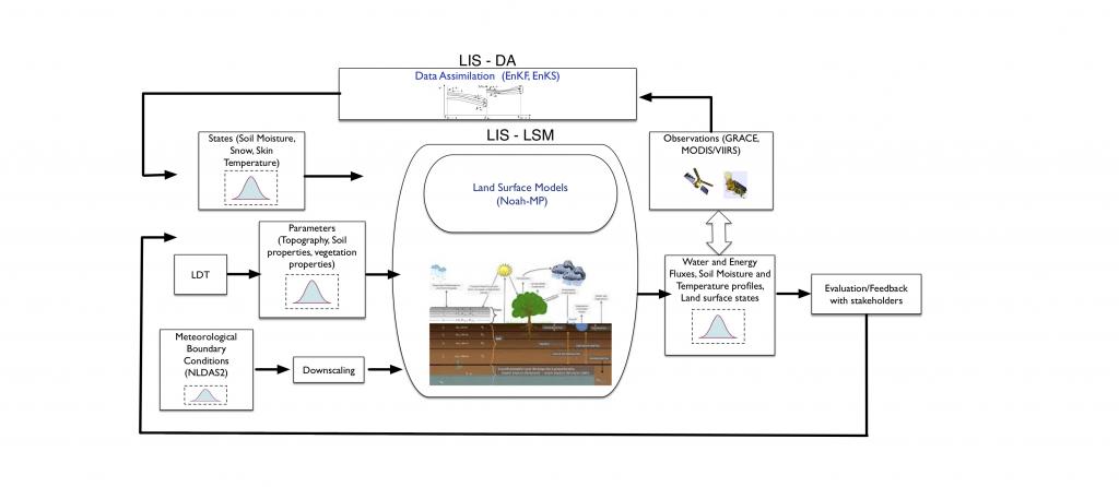
WLDAS uses NASA’s Land Information System (LIS) to configure and drive the Noah Multiparameterization (Noah-MP) Land Surface Model to simulate land surface states and fluxes. Satellite data are used to parameterize and force the model and are also integrated using data assimilation. Our partners are active in evaluating model performance.
WLDAS uses meteorological observables including precipitation, incoming shortwave and longwave radiation, near surface air temperature, humidity, wind speed, and surface pressure along with parameters such as vegetation class, soil texture, and elevation as inputs to a model that simulates land surface energy and water budget processes. Outputs of the model include soil moisture, snow depth and snow water equivalent, evapotranspiration, soil temperature, as well as derived quantities such as groundwater recharge and anomalies of the state variables.
Questions about WLDAS can be directed to lead researchers Jessica Erlingis and Bailing Li or Project PI Matt Rodell .