

NLDAS Soils Datasets and Illustration
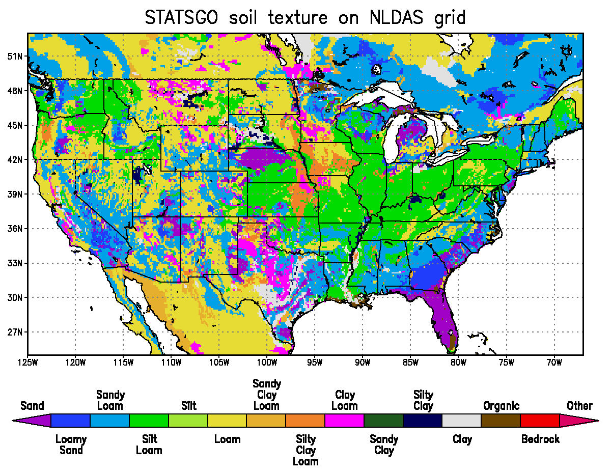
The soils data used for NLDAS within CONUS were derived from 1-km Penn State STATSGO data and have 16 texture types.
Outside of the United States, 5-minute ARS FAO data was used instead.
The STATSGO dataset soil texture types are:
 Index   Texture
 -----   -------
   1     SAND
   2     LOAMY SAND
   3     SANDY LOAM
   4     SILT LOAM
   5     SILT
   6     LOAM
   7     SANDY CLAY LOAM
   8     SILTY CLAY LOAM
   9     CLAY LOAM
  10     SANDY CLAY
  11     SILTY CLAY
  12     CLAY
  13     ORGANIC MATERIAL
  14     WATER
  15     BEDROCK
  16     OTHER(land-ice)
NLDAS Soil Texture Types Dataset
- NLDAS soil texture data (netCDF-4 format)
NLDAS Soil Texture Types Illustration
NLDAS Land-Surface Model-specific Information
Additional details about LSM-specific soil parameters can be found in Paragraph 10 of Mitchell et al. (2004) as well as in Section 5.1 of Robock et al. (2003).
NLDAS Mosaic Soil Hydraulic Properties Dataset
The Mosaic LSM was configured for NLDAS to have 3 soil moisture layers with thicknesses (from top) of 10cm, 30cm, and 160cm - for a total soil column depth of 2 meters. All 3 soil layers use the same soil texture (predominant surface soil classes shown above) and thus use the same soil parameter values for all layers as well. The one exception is the soil porosity in Mosaic, which is calculated for each of the 3 layers based on a weighted average from the 11-layer STATSGO soil textures. The field capacity is not directly used within Mosaic, but is provided below for all three soil layers, based on Equation 20 in Mocko and Sud (1998). The wilting point in Mosaic is a function of both the vegetation type and the soil type. Because Mosaic is run with vegetation tiling (multiple vegetation tiles within a single NLDAS grid box), the weighted average of the wilting point for all vegetation types within the grid box is provided. A lookup table and calculations based on soil texture class(es) are used in the Mosaic code, but maps of the NLDAS Mosaic LSM soil parameter values are provided below:
- NLDAS Mosaic soil parameters (netCDF-4 format)
NLDAS Noah Soil Hydraulic Properties Dataset
The Noah LSM was configured for NLDAS to have 4 soil moisture layers with thicknesses (from top) of 10cm, 30cm, 60cm, and 100cm - for a total soil column depth of 2 meters. All 4 soil layers use the same soil texture (predominant surface soil classes shown above) and thus use the same soil parameter values for all layers as well. A lookup table and calculations based on soil texture class are used in the Noah code, but maps of the NLDAS Noah LSM soil parameter values are provided below:
- NLDAS Noah soil parameters (netCDF-4 format)
NLDAS VIC Soil Hydraulic Properties Datasets
Soil parameter information specific for the NLDAS version of the VIC LSM is available from the Princeton NLDAS parameter page.
NLDAS SAC Soil Hydraulic Properties Datasets
Soil parameter information specific for the NLDAS version of the SAC LSM will appear here at a later date.